Aerial Surveying, Imaging, and Cinematography in Burlington
Vermont Aerial Observation Solutions
Burlington Helicopter Charters delivers comprehensive aerial survey capabilities across Vermont, encompassing advanced geophysical methodologies such as magnetometer and electromagnetic surveys, LiDAR data acquisition, and precise GIS mapping. Our services leverage the inherent low-altitude flight and stable hover characteristics of helicopters, providing unmatched operational flexibility for detailed data collection. Furthermore, we specialize in high-definition aerial cinematography and photography, offering access to advanced imaging technologies. This includes the provision of aircraft configured for specialized camera mounts or door-off operations for handheld precision, catering to the exacting demands of professional visual content creation. For critical data capture or visual documentation projects throughout Vermont, our solutions are meticulously tailored.

Aerial
Surveys
LiDAR, GIS Maps, FLIR, HD Video & More
Burlington Helicopter Charters provides critical aerial support for a range of infrastructure maintenance tasks, including rigorous pipeline inspections, comprehensive Right-of-Way (ROW) assessments, and routine transmission line patrols. We ensure the deployment of appropriately configured aircraft equipped with specialized sensing and imaging technology, facilitating precise and efficient project execution for our clients throughout Vermont.
High Tech Results
The Top Pilots in Vermont, Today's Technology... Maximum Results.
Call 1-866-826-4826 Now!
Burlington Helicopter Charters provides the tools needed to complete your land surveys, utilizing the right equipment to provide the aerial photos that are often needed.
Precision aerial surveys significantly enhance the efficiency and accuracy of Right-of-Way (ROW) and site inspections, the acquisition of critical topographical data, and the capture of high-definition imagery for commercial development projects. Helicopters are inherently suited for inspecting extensive infrastructure like pipelines for anomalies or detecting operational issues on transmission lines across the Vermont landscape. Burlington Helicopter Charters specializes in designing bespoke photographic and remote sensing operations. These customized solutions are engineered to optimize both technical and financial efficiency, ensuring superior data capture and analytical results for complex commercial and industrial applications throughout Chittenden County and beyond.
Rotary-wing aircraft offer distinct operational advantages over fixed-wing platforms for aerial surveying, primarily due to their superior low-altitude and slow-flight capabilities. While Federal Aviation Administration (FAA) regulations typically mandate a minimum altitude of 1,000 feet above the highest obstacle for fixed-wing aircraft, helicopters can safely operate at significantly lower altitudes. This critical operational flexibility enables close-range inspection of challenging or hazardous zones, providing engineers with an otherwise unattainable vantage point for detailed analysis and data acquisition, crucial for projects throughout Vermont.
There is no better way to conduct your visual survey, animal population counts, soil drainage analysis, ROW inspections, pipeline and transmission line inspections, and geographical surveys.
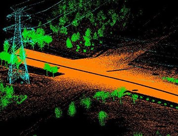
LiDAR Imaging
Light Detection and Ranging, or LiDAR, is a remote sensing method used to examine and measure Vermont topography as well as objects, like vegetation, upon it.

Infrared Imaging
Thermographic IR cameras are used to detect radiation in the long-infrared range of the electromagnetic spectrum and produce images of that radiation, called thermograms.

HD Video Gimbal Capture
Modern HD and 4K cameras can be mounted to helicopters, using the proper STCs, with a gimbal to stabilize photos & videos for detailed results.

Advanced Aerial Cinematography and Professional Imaging
For expert camera work in the Burlington Sky
Get a Fast, free QuoteBurlington Aerial Cinematography
Burlington Helicopter Charters provides comprehensive access to advanced resources essential for professional-grade aerial cinematography across Vermont. We facilitate specialized custom shoots by deploying state-of-the-art gyro-stabilized camera mounts, including industry-standard systems such as Tyler Mounts, Wesscam, Cineflex, Pictorvision, and SpaceCam. These platforms are integrated with high-performance specialty cameras like the Cineflex HD, RED Epic, and Arri Alexa, alongside capabilities for 3D and experimental imaging configurations. Our support extends to all facets of your production goals, from dynamic air-to-air sequences to precise ground-to-air shots. We understand the critical collaboration required between flight operations and your aerial Directors of Photography and directors to achieve desired visual outcomes. Specializing in providing rotary-wing platforms for both still and motion photography, Burlington Helicopter Charters can support a vast spectrum of media-related operations throughout Vermont. This includes feature film productions, television series, documentary projects, compelling promotional videos, high-impact commercials, the strategic placement of aerial props, critical relief work for broadcast networks, and comprehensive coverage of historical events or major sporting competitions, utilizing a diverse fleet of specialized helicopters configured for optimal performance.
Call Us Today at 1-866-826-4826 for a Free Quote
Contact Us
Aerial Photos
Hand-held or Mounted OpTions in Burlington
We will help you get the right equipment for your aerial photography project! Call 1-866-826-4826 today to get a fast, free quote.
The Most Options for Photography
For capturing the intricate details and expansive vistas of Vermont, an aerial perspective often proves indispensable. Burlington Helicopter Charters facilitates aerial photography missions engineered to meet rigorous technical specifications and achieve precise visual objectives. We provide cost-effective photographic opportunities, deploying helicopters configured for optimal imaging. Many rotary-wing aircraft can be prepared for door-off operations, enabling maximum flexibility for handheld photographic assignments. For projects demanding superior stability and cinematic quality, advanced gyro-stabilized camera mounts are available, ensuring the capture of exceptionally smooth and precise imagery. Our solutions are designed for professionals seeking high-quality aerial documentation across Burlington, the Lake Champlain region, and throughout the Green Mountain State.
Superior Service
Every one of our customers gets a dedicated helicopter expert to assist with flight plans, tech loadouts, production logistics, project schedules, and other demands.
Over 500 Aircraft
Our network of direct air partners extends well beyond Burlington, Vermont. This allows us to offer a wide range of solutions for even the most sophisticated projects.
The Best Equipment
From high-tech sensors like LiDAR, FLIR, and GIS to HD cameras and movie production gimbals, we're here to make your job as easy as possible.